
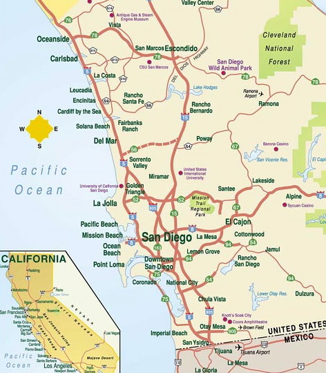
Because someone emailed me asking how close we were to the fires. Okay. I’ll walk you through the map, if you want. Maybe this will give you some frame of reference for any of the city names you’ve heard thrown around on the news. (I had to crop it to fit the frame here, but it’s got the pertinent areas on it.)
— See where it says San Diego and Downtown San Diego? We live right in between those 2 labels, basically. So unless our canyon catches on fire, we’re not in any fire danger.
— Follow me north from there now. There are fires burning in or near the areas of Fairbanks Ranch, Rancho Santa Fe — both extreeeemely wealthy neighborhoods — and most of those north coastal towns are under mandatory evacuations, from Del Mar to Carlsbad. Officials were concerned about the fire jumping the I-5, the main north/south artery there, which would be unprecedented. And almost unfathomable. That hasn’t happened, thank God.
Confused yet?
— Okay. Now move your eyes east of there to Rancho Bernardo and Ramona — both hit terribly hard. (For those of you who watched Katie Couric on the news tonight, she was broadcasting from Escondido — north from where you are now and smack dab in the middle of the map.)
— Now let’s go south back to San Diego. (Just consider this eyeball aerobics. It’s good for you. I mean, probably.) From San Diego, move slightly southeast to Rancho San Diego and Jamul. Fires raging all around that area.
— To give you an idea of distances, the private school were I taught performing arts a few years ago is in Solana Beach, just above Del Mar. That’s 20 miles away from me.
— My brother and wife and The Banshee north up the I-5 in Encinitas, oh, 25 miles away. My mom and dad live east in El Cajon, about 10 miles from me. Sister lives in Orange County, not on this map, but with its own issues right now.
— Oh, and last thing. See that yellow triangle at the very northwest corner of the map? Again, I had to crop this map, but that designates the start of the Camp Pendleton Marine Base. There’s now a fire burning up there.
— Just picture the fires basically forming an arc, a backwards ‘C’, facing the ocean, starting north and running south. That’s my best description of what’s going on here.
Uhm, don’t know if this served any real purpose for any of you, but there it is!
Thanks Tracey, that does help put it all in perspective. I heard somewhere that they may be looking at this as a terrorist attack not just as arson…have you heard anything about that out there?
I heard on our local news last night that if all the acreage of fires in California were put together in one spot, the entire metropolitan area of Seattle from Tacoma to Everett and east to North Bend would be gone. It’s huge!
I’ve got an aunt in El Cajon. She left her house and stayed with my cousin in San Diego for a while, but I believe she was going back to her own house yesterday or today. Thanks for the map and the clarification. And I’m glad you and yours are all okay.
No, really, it did. Thanks for the insider’s view!
sam — I’ve heard rumblings, but not from any official authority. Just from pissed-off people. So it’s kind of wait-and-see on that.
Anita – Wow! See, that even helps ME grasp it better. I’m more familiar with that than I am some of the outlying areas of San Diego. (Which is strange, I guess, considering I grew up here.)
jayne — I’m glad your aunt is okay. My parents didn’t evacuate, but that situation out there keeps changing with the wind.
Kate P- Thanks. I’m glad it helped.
We mailed stuff out to Poway School District from my workplace. I didn’t realize it was quite that close. I hope they’re OK. What a nightmare.
Oy. [shaking head] I’m speechless. (For once.)
Although, if you’ll pardon me, all this “Ranchero” stuff has got me wanting Mexican food. 😉